Weather
The home screen is the glance. These are the pages behind it.
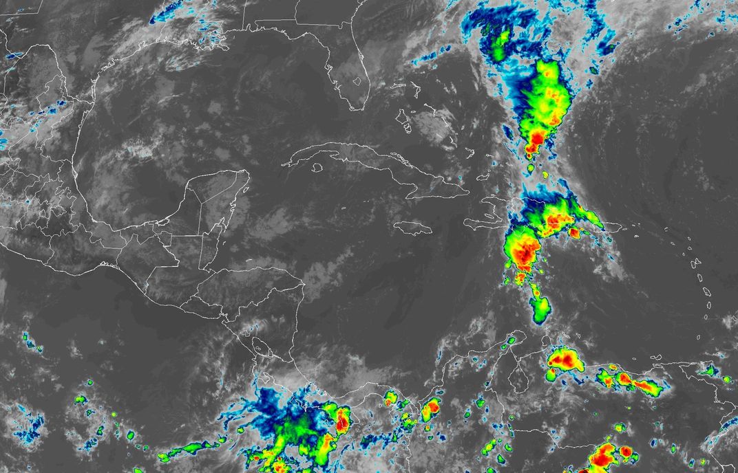
Satellite clouds around Belize
Tue 2:20 PM
Pinch or scroll to zoom, drag to move, double-tap to zoom in.
grey: low clouds or cleargreen / yellow: showersred / black: strong storms, very cold cloud tops
Colour means a tall cloud: green, then yellow, red and black for the highest, coldest tops, with the heaviest rain and lightning underneath. Watch which way the coloured patches drift to see where the storms are heading; San Pedro is the yellow ring.
The clouds as your eye would see them from space. At night the picture switches to infrared, with city lights on the ground; San Pedro is the yellow ring.
Imagery: NOAA/NESDIS STAR, GOES-19 (public domain)
Rain gauges measured on the island
Island rain is very patchy: a shower can soak one end of the island and miss the other, so gauges a mile apart often differ a lot.
South End stationUpdated 2:35 PM
Today0.00″0.0 mmsince midnight
Last 24 hours0.00″0.0 mm
Last 7 days0.23″5.8 mm
This month9.27″235.5 mmsince Oct 6
Rate now: 0.00″/h 0.0 mm/h
Last rain: 0.09″ over 30 min, Fri 12:30 AM – Fri 1:00 AM 2.3 mm
San Pedro AirstripOffline since 6:45 AM
Today0.00″0.0 mmsince midnight
Last 24 hours0.00″0.0 mm
Last 7 days0.25″6.4 mm
This month7.67″194.8 mmsince Oct 8
Last rain: 0.07″ over 45 min, Sat 3:15 PM – Sat 4:00 PM 1.8 mm
Belize Pulse station (South)Updated 2:42 PM
Today0.00″0.0 mmsince midnight
Last 24 hours0.00″0.0 mm
Last 7 days0.35″8.9 mm
This month3.26″82.8 mmsince Oct 17
Rate now: 0.00″/h 0.0 mm/h
Last rain: 0.04″ over 6 h 25 min, Sat 3:39 PM – Sat 10:04 PM 1.1 mm
South End station: a private station on the south end, shared with the owner's permission. San Pedro Airstrip: National Meteorological Service of Belize. Belize Pulse station: our own WeatherFlow Tempest on the south end.
Today = since midnight Belize time. A rain event ends after 6 dry hours. We began recording in early October 2026, so longer totals start from the date shown. JSON
Right now, in detailMeasured station readings, rain next 3 hours, lightning, reef waves, tides, Met Service text, radar loops, and the 7-day table.
Forecast, model by modelECMWF, GFS, ICON and the AI model side by side for 7 days, with where they agree and where they don't.
Tropics & stormsNational Hurricane Center systems, distance from Belize, and what the Met Service is saying.
Met Service forecastThe National Meteorological Service of Belize forecast, marine forecast and radar, quoted in full.
Sky moodsThe seven backgrounds the home screen chooses from, and when each appears.
Developers: JSON of everything on the home screen.